Add your promotional text...
Lecture 38: The "Lost" Rivers of the Sahara: Reactivation and Consequences
Series: The Sahara Reforestation Project: From Dune Sea to Green Valley Part IV: Advanced Bioscience and Geopolitics
5/25/20266 min read
Introduction: Echoes of a Fluvial Past
Welcome. Our discourse on the hydrological engineering of the Sahara has, until now, been one of deliberate creation. We have designed a grid of pipelines and canals to impose a new circulatory system upon the desert, and we have planned the engineering of new river channels to guide the flow of this imported water. However, the Sahara is not a blank geological slate. Buried beneath its vast sand seas lies a ghost of a far wetter past: a complex, continent-spanning network of ancient river systems, known as paleochannels.
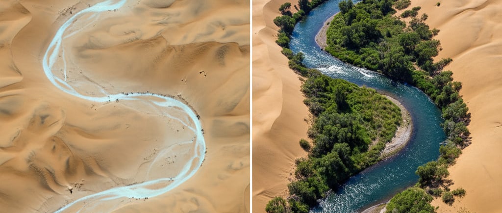
These "lost" rivers, legacies of the African Humid Period and earlier wet phases, did not vanish without a trace. They left behind immense, buried channels filled with permeable sediments, and they carved the very bedrock of North Africa. As the Sahara Reforestation Project proceeds, and the regional water table begins to rise from decades of irrigation and altered climate, we will not only be filling our engineered rivers; we will be unintentionally reawakening these dormant fluvial giants.
This lecture will explore the profound geological and ecological consequences of reactivating the Sahara's paleochannel network. We will delve into the remote sensing techniques used to map these subterranean systems, model the hydrogeological process of their reactivation, and analyze the immense opportunities and significant risks that this re-emergence will present. This is not just a side effect of our project; it is a geological-scale event that we must anticipate, manage, and integrate into our terraforming strategy.
Mapping the Ghost Rivers: The View from Space
The primary evidence for these ancient river systems comes from advanced remote sensing technologies, particularly Shuttle Imaging Radar (SIR) and other forms of spaceborne radar. Unlike optical satellites, which see only the surface, radar can penetrate several meters into the dry, loose sand of the desert.
The Mechanism of Radar Penetration: The microwaves emitted by the radar pass through the dry sand, which is largely transparent to these wavelengths. They then reflect off the denser, buried bedrock and the coarse, gravelly sediments that fill the ancient river channels.
The resulting imagery is a ghostly, high-resolution map of the underlying topography. It reveals, in stunning detail, a complex dendritic network of river valleys, tributaries, and deltas, a landscape of fluvial erosion that is completely invisible to the naked eye.
Major Identified Systems: Through this technology, scientists have mapped several enormous paleochannel systems, including:
The Tamanrasset River: An immense system that once flowed from the Atlas and Hoggar mountains in the central Sahara, west across Mauritania, to a massive delta on the Atlantic coast. It was a river that likely rivaled the modern-day Nile or Amazon in scale.
The Irharhar River: A paleoriver that flowed south from the Hoggar Mountains towards the Sahel.
Kufra River System: A network in the eastern Sahara that flowed north from the Tibesti mountains towards the Mediterranean.
These radar maps provide us with a geological blueprint of the Sahara's natural, pre-desert drainage patterns.
The Process of Reactivation: A Rising Water Table
The reactivation of these paleochannels will be a slow, multi-stage process, driven by the project's fundamental alteration of the regional hydrology.
Saturation of the Paleochannel Sediments: The paleochannels are filled with highly permeable alluvial deposits (gravels and coarse sands). As the regional water table rises from deep percolation and aquifer recharge, these ancient riverbeds will be the first and most conductive pathways to saturate. They will become vast, linear, subterranean aquifers, channeling groundwater along their ancient paths.
Emergence of Springs and Seeps: As the water level within these linear aquifers continues to rise, it will eventually intersect with the surface topography. This will lead to the spontaneous emergence of lines of springs and seeps along the traces of the paleochannels, creating linear wetlands and oases.
Baseflow and the Birth of Perennial Rivers: Once the water table is consistently above the channel bed, groundwater will continuously feed into the channel, creating a stable "baseflow." At this point, the river is reborn as a perennial, groundwater-fed waterway. This process will be accelerated by the increased surface runoff from the new, localized rainfall patterns, which will naturally be captured by these same topographical lows.
Instead of needing to excavate entirely new river channels (as discussed in Lecture 21), our primary strategy will shift to simply "unclogging" and vegetating these naturally re-emerging paleochannels.
The Consequences: Opportunities and Hazards
The reactivation of these river systems presents a suite of transformative opportunities, but also significant geological and engineering hazards that must be managed.
Opportunities:
A Natural, Low-Energy Water Grid: The paleochannel network is, in effect, a pre-existing, gravity-driven water distribution system. Once reactivated, these rivers will transport water across vast distances with zero energy input, dramatically reducing the long-term reliance on the energy-intensive pumped pipeline grid.
Hyper-Fertile Agricultural Corridors: The alluvial sediments filling the paleochannels are the most fertile substrates in the entire desert. They are richer in silt, clay, and organic matter (from their previous life) than the surrounding sandy plains. The reactivated river corridors, with their constant water supply and fertile soils, will become the premier agricultural zones of the new Sahara, ideal for intensive horticulture and agroforestry.
Biodiversity Superhighways: These re-established river corridors will be the most biodiverse and productive ecosystems in the landscape. They will act as natural, continent-spanning conservation corridors, providing a protected pathway for the migration and dispersal of a vast array of aquatic and terrestrial species.
Access to Mineral Deposits: Ancient river systems are known for creating "placer deposits"—concentrations of heavy minerals, which can include valuable resources like rare earth elements, titanium, and gold, washed down from the mountain ranges over millennia. The reactivation process may expose or make these deposits more accessible.
Hazards:
Uncontrolled Flooding and Channel Migration: A newly re-emerging river is a dynamic and unstable entity. In its early stages, before a stabilizing riparian ecosystem is established, it will be prone to flash floods, rapid bank erosion, and avulsion (the sudden abandonment of a channel in favor of a new one). This poses a significant risk to any infrastructure built within or near the paleochannel.
Liquefaction and Geotechnical Instability: The rapid saturation of thick layers of previously dry, loose sand and sediment can lead to soil liquefaction, a process where the soil temporarily loses its strength and behaves like a liquid. This could cause the catastrophic collapse of any buildings, pipelines, or transport routes built over the reactivating channels.
Remobilization of Ancient Salts: The paleochannel sediments may contain large deposits of evaporite minerals (salts) from their last drying phase. The re-emerging groundwater will dissolve these ancient salt lenses, potentially creating plumes of highly saline water that could contaminate downstream ecosystems or agricultural zones if not properly managed.
Ecological Mismatches: The geochemistry of the re-emerging deep groundwater may be different from the surface water, potentially creating ecological challenges at the interface.
A Proactive Management Strategy
To harness the opportunities while mitigating the hazards, a proactive management strategy is essential.
Predictive Geotechnical Modeling: The entire paleochannel network, as mapped by radar, will be subject to intensive geotechnical modeling. This will be used to create a detailed "hazard map," identifying areas at high risk for liquefaction or channel migration. All major infrastructure will be routed to avoid these high-risk zones.
Engineered "Pilot Channels": Instead of waiting for the rivers to emerge uncontrollably, we will engineer smaller "pilot channels" within the main paleochannels. These channels will be stabilized with bio-engineering techniques (planting willows, reeds, etc.) and will be designed to safely convey the initial baseflow and minor flood events.
Accelerated Riparian Restoration: As soon as baseflow begins, we will launch an aggressive riparian afforestation program along the entire length of the reactivated channel. The rapid establishment of a dense, deep-rooted forest is the primary and most effective long-term strategy for stabilizing the riverbanks and creating a resilient channel.
Real-Time Monitoring Network: A network of piezometers (to monitor groundwater pressure), stream gauges, and satellite-based interferometric synthetic-aperture radar (InSAR, to detect ground subsidence) will provide a real-time, continent-scale view of the reactivation process, allowing for an adaptive management response.
Conclusion: Reawakening the Land's Memory
The reactivation of the Sahara's lost rivers is perhaps the most poetic and profound consequence of our terraforming project. It is the moment the land itself begins to reawaken its own deep memory of a wetter, more vibrant past. This process transforms our endeavor from one of purely imposing a new system upon a static landscape to one of working in partnership with the land's own inherent geological and hydrological tendencies.
By mapping these ghost rivers, we are given a blueprint for the most efficient and natural layout for our new biosphere's circulatory system. By proactively managing their re-emergence, we can harness their power to create hyper-productive ecological and agricultural corridors, dramatically accelerating the greening process and enhancing its long-term stability.
The hazards are significant, demanding a new level of integration between hydrological engineering, geotechnical science, and restoration ecology. But the prize is immense: the transformation of our engineered water grid into a network of living, breathing, largely self-sustaining rivers. This is a critical step towards the ultimate goal of a fully independent and resilient Saharan ecosystem.
Our next lectures will continue to explore the advanced biological and ethical frontiers opened up by such a profound transformation. Thank you.